NAVTEX broadcasts
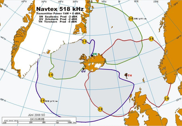
Navtex transmissions to Navera region 1 N-Europe.
Navtex in an international communication standard that transmits information at sea in the form of printed messages. In this way, important information, such as the weather, can be communicated directly to seafarers in an easy and secure way.

Navtex transmissions to Navera region 1 N-Europe.
| Nafn stöðvar | Einkenni | Útsendingatímar |
|---|---|---|
| Svalbard | A | 0000, 0400, 0800, 1200, 1600, 2000 |
| Bodö radio | B | 0010, 0410, 0810, 1210, 1610, 2010 |
| Murmansk radío | C | 0020, 0420, 0820, 1220, 1620, 2020 |
| Tórshavn | D | 0030, 0430, 0830, 1230, 1630, 2030 |
| Niton (UK) | E | 0040, 0440, 0840, 1240, 1640, 2040 |
| Arkangelsk | F | 0050, 0450, 0850, 1250, 1650, 2050 |
| Cullercoats radio | G | 0100, 0500, 0900, 1300, 1700, 2100 |
| Bjuröklubb*. | H | 0110, 0510, 0910, 1310, 1710, 2110 |
| Grimeton*. | I | 0120, 0520, 0920, 1320, 1720, 2120 |
| Gislövshammar* | J | 0130, 0530, 0930, 1330, 1730, 2130 |
| Nitton (France) | K | 0140, 0540, 0940, 1340, 1740, 2140 |
| Rogaland radio | L | 0150, 0550, 0950, 1350, 1750, 2150 |
| Ostende radio | M | 0200, 0600, 1000, 1400, 1800, 2200 |
| Örlandet | N | 0210, 0610, 1010, 1410, 1810, 2210 |
| Portpatrick | O | 0220, 0620, 1020, 1420, 1820, 2220 |
| Netherland C G | P | 0230, 0630, 1030, 1430, 1830, 2230 |
| Malin Head | Q | 0240, 0640, 1040, 1440, 1840, 2240 |
| Ísland/Grænland Sauðanes | R | 0250, 0650, 1050, 1450, 1850, 2250 |
| Ostende radio | T | 0310, 0710, 1110, 1510, 1910, 2310 |
| Talinn | U | 0320, 0720, 1120, 1520, 1920, 2320 |
| Vardö radio | V | 0330, 0730, 1130, 1530, 1930, 2330 |
| Valentia | W | 0340, 0740, 1140, 1540, 1940, 2340 |
| Ísland/Grænland Grindavík | X | 0350, 0750, 1150, 1550, 1950, 2350 |
| Nafn stöðvar | Einkenni | Útsendingatímar |
|---|---|---|
| John´s r. NF | O | 0220, 0620, 1020, 1420, 1820, 2220 |
| Grænland (vesturströnd) | V | 0340, 0740, 1140, 1540, 1940, 2340 |
Note : Message groups A, B, and D along with L associated with A cannot be deleted.
Transmitter stations (B1) kHz. Broadcast times. Message categories (B2).
A = Navigation warnings.
B = Storm or weather warnings.
C = Ice reports.
D = Search and rescue. Armed robbery and more.
E = Weather forecasts.
F = Navigation service.
J = About satellite positioning.
K = Warnings due to other electronic navigation systems.
L = Alerts due to rig movements.
V = Imminent maritime safety hazard, see A.
X = Various announcements according to government orders.
Z = No messages are available.
Transmission locations for Navtex from the Icelandic Maritime Traffic Service are:
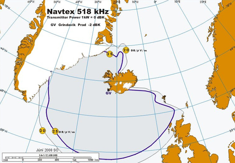
Grindavík with the identifying letter X at 518kHz and K at 490kHz
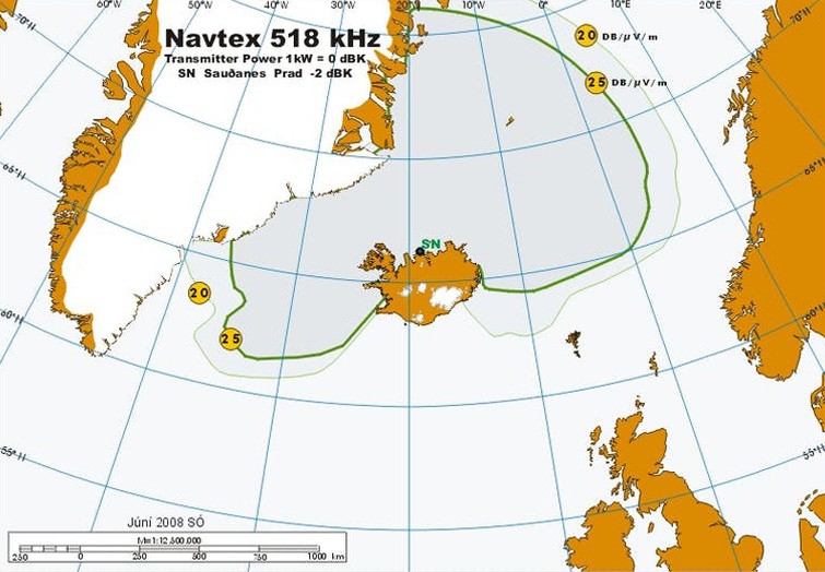
Sauðanes with the identifying letter R at 518kHz and E at 418kHz

From Grindavík, transmissions are sent at 518kHz in English and 490kHz in Icelandic.
The transmission times are:
Grindavik [X] 518 kHz 0350, 0750, 1150, 1550, 1950, 2350 UTC
Grindavik [K] 490 kHz 0140, 0540, 0940, 1340, 1740, 2140 UTC

From Sauðanes transmission are sent at 518kHz in English and 490kHz in Icelandic.
The transmission times are:
Saudanes [R] 518 kHz 0250, 0650, 1050, 1450, 1850, 2250 UTC
Saudanes [E] 490 kHz 0040, 0440, 0840, 1240, 1640, 2040 UTC

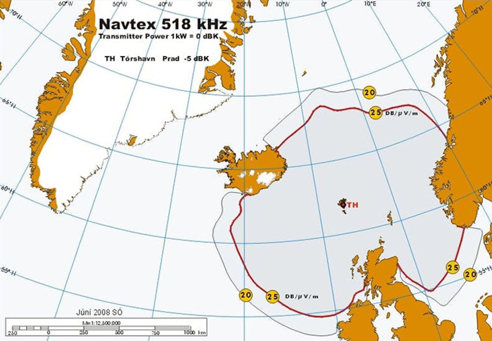
From Tórshavn transmissions are sent at 518kHz in English.
The transmission times are:
Tórshavn [D] 518 kHz 0030, 0430, 0830, 1230, 1630, 2030 UTC
